सञ्चिका:Bangalore1924 map.png

अस्य पूर्वावलोकनस्य आकारः : ६३८ × ५९९ पिक्सेल् अन्याः प्रस्तावाः: २५५ × २४० पिक्सेल् | ५११ × ४८० पिक्सेल् | ९११ × ८५६ पिक्सेल् ।
मूलसञ्चिका (९११ × ८५६ चित्राणवः (pixels), सञ्चिकायाः आकारः: ५८९ KB, MIME-प्रकारः: image/png)
| Description | ||||||||||
| दिनाङ्क | ||||||||||
| स्रोतः | http://en.wiki.x.io/wiki/File:Bangalore1924_map.gif | |||||||||
| रचियता | ||||||||||
| Geotemporal data | ||||||||||
| Bounding box |
|
|||||||||
| Georeferencing | ||||||||||
अनुमतिदानम्
यह रचना भारत में सार्वजनिक अधिकार में है क्योंकि इसके कॉपीराइट की अवधि समाप्त हो गयी है। भारतीय कॉपीराइट अधिनियम भारत में लागू होता है उन रचनाओं पर काम करता है जो सबसे पहले भारत में प्रकाशित हों। भारतीय कॉपीराइट अधिनियम, 1957 (अध्याय V धारा 25), अनाम रचना, तस्वीरों, छायांकन, ध्वनि रिकॉर्डिंग, सरकारी दस्तावेज़, और कॉर्पोरेट ग्रन्थकारिता की या अंतरराष्ट्रीय संगठनों पर काम करता है की तारीख 60 वर्ष के बाद सार्वजनिक अधिकार में प्रवेश हो जाते हैं।
|
 |
मूलनिवेशनप्रणाली
The original description page is/was here. All following user names refer to en.wikipedia.
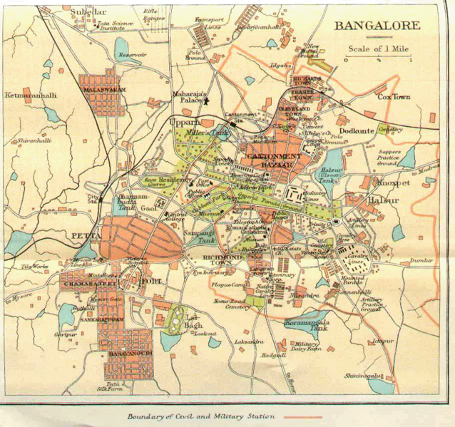
- 11 février 2006 à 03:22 AreJay (911 × 856 pixels, taille du fichier : 548 Kio, type MIME : image/gif) (Historical Map of Bangalore, India, circa 1924. This is a low-quality scan of a 1924 city map from "Murray's 1924 Handbook". No copyrights appear to have been asserted by the individual that has scanned the map. )
मूलनिवेशनप्रणाली
| दिनाङ्कः/समयः | आयामाः | सदस्यः | टिप्पणी |
|---|---|---|---|
| ११ अक्टोबर् २००९, १२:५२:१९ | 911 × 856 (561460 bytes) | Elvire (सम्भाषणम् · योगदानानि) | {{Information |Description=Historical Map of [[Bangalore]], [[India]], circa [[1924]]. |Source=http://en.wiki.x.io/wiki/File:Bangalore1924_map.gif |Date=1924 |Author=[http://en.wiki.x.io/wiki/File:Bangalore1924_map.gif ?] |Permission=Voir ci-desso |
सञ्चिकायाः इतिहासः
सञ्चिका तत्समये कीदृशी आसीदिति द्रष्टुं दिनाङ्कः/समयः नुद्यताम् ।
| दिनाङ्कः/समयः | लघ्वाकृतिः | आयामाः | सदस्यः | टिप्पणी | |
|---|---|---|---|---|---|
| वर्तमानः | १७:५८, २३ आगस्ट् २०१४ | | ९११ × ८५६ (५८९ KB) | GifTagger | Bot: Converting file to superior PNG file. (Source: Bangalore1924_map.gif). This GIF was problematic due to non-greyscale color table. |
सञ्चिकायाः उपयोगः
अधोलिखितं पृष्ठं इदं संचिकां प्रति संबंधनं करोति।
वैश्विकसञ्चिकायाः उपयोगः
एतां सञ्चिकाम् अधोनिर्दिष्टाः वीक्यः उपयुञ्जते:
- af.wiki.x.io इत्यस्मिन् उपयोगः
- en.wiki.x.io इत्यस्मिन् उपयोगः
- gl.wiki.x.io इत्यस्मिन् उपयोगः
- kn.wiki.x.io इत्यस्मिन् उपयोगः